 05/10/2023

In May 2022, the wastewater seeped around the house of Haidar and 40 houses of his neighbors in the Wafla area, in the villages of Al- Maraqi. The brackish water was rising slowly but surely in his village west of Siwa – an ancient Egyptian farming oasis hundreds of kilometers away from Cairo, almost touching the Libyan border.
And this wasn’t the first time. Haidar is in his 50s today, but a quarter of a century ago the same exact thing had happened: his family’s land full of olive trees, palm trees, pomegranate trees, some 60 years old, have become drown, and everyone had to pick up and leave. It was a year after the village elders of Siwa had met with the late President Hosni Mubarak to ask him to help save Siwa in April 1996.
The elders had known for decades that the agricultural run-off water was drowning their oasis, which lies 17 meters below sea level. Even though Siwa had been a farming oasis in the middle of the desert for thousands of years, but this time, it was in danger of dying off, once and for all.
Mubarak then, tasked two of his ministers – Defense and Irrigation, both of whom had accompanied him on his visit to Siwa in April 1996 – to figure out a solution and to put all needed resources in place, in coordination with the cabinet.
The requests for help have not stopped since then, and in March 2018, the village elders – who represent the 35,000 residents of Siwa – met with the current president, Abdel Fattah Sisi. They explained how the measures taken so far have only made their problems worse, according to Sheikh Omar Raji’, the head of Awlad Musa tribe, and chieftain of all tribes in Siwa who attended both presidential meetings.
During the meeting, Al-Sisi assigned one of his advisors to study the issue and reportedly said, “This problem that they couldn’t solve for 30 years – we will solve it.”

Both presidents announced plans to make agricultural investments in Siwa and its surrounding area (about 94,000 square kilometers), but the victims of these investments have been the residents. Their land has been hardest hit by the agricultural drainage issues, and consistently have been losing productivity. Meanwhile, the massive new developments managed by big investment corporations – promoted by successive Egyptian governments – are thriving.
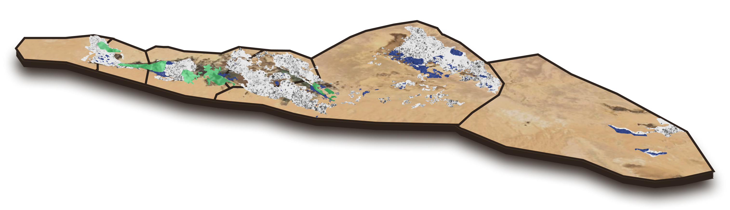
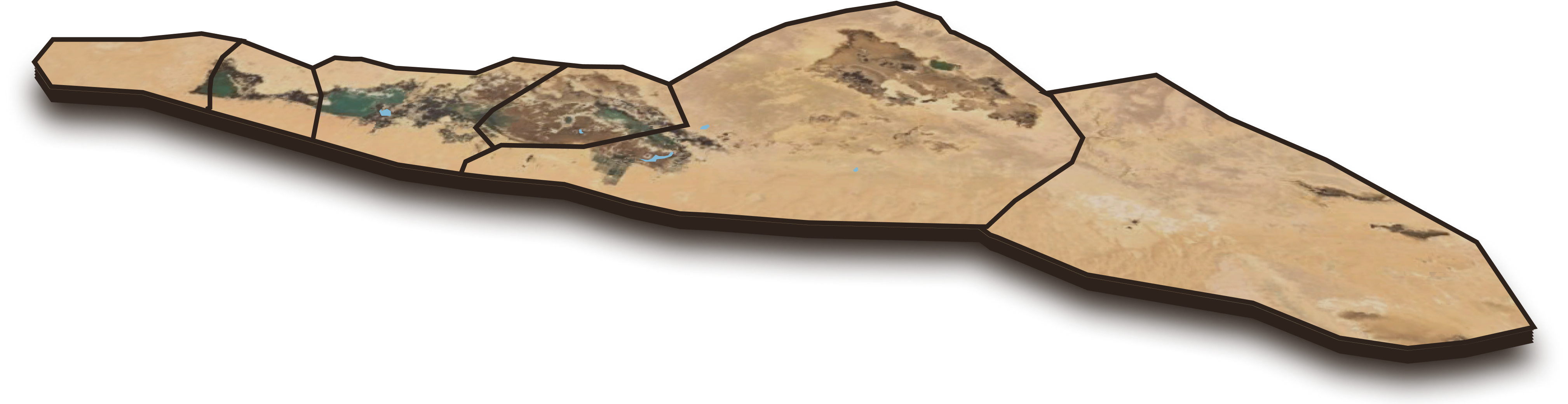
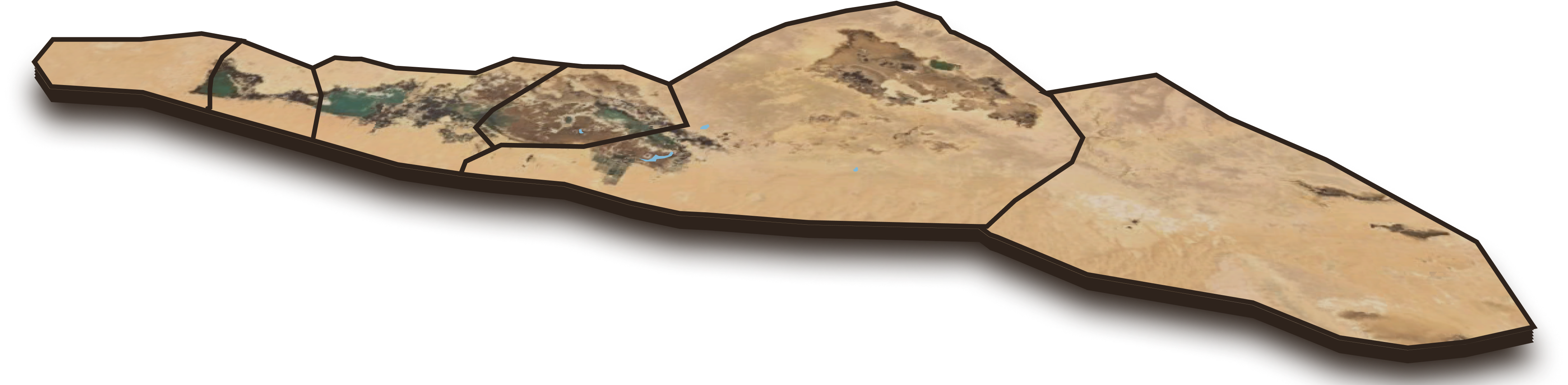
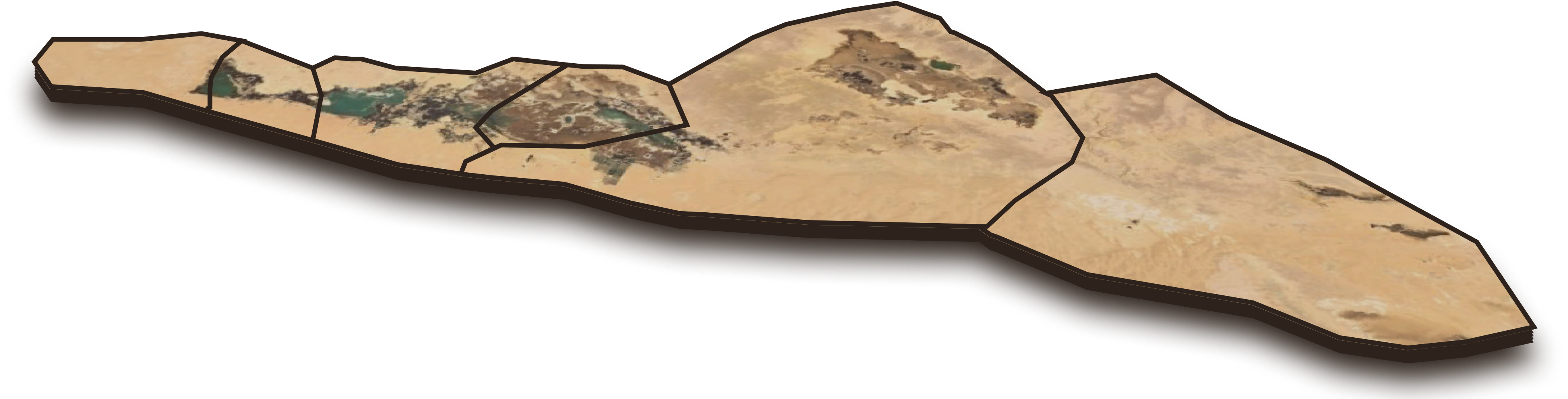
To document the deterioration to the land over time, this report used studies produced by experts, satellite imagery from Landsat, and geographical information software including ArcGIS, Google Earth and ENVI.
All indications point to a 57% increase in unfarmable land between 1990-2021. Surface water area has increased also by 58%, according to satellite imagery, which has destroyed natural resources and harmed the residents. The agricultural drainage is threatening to force families like the Haidars to move again.

Click to browse the years
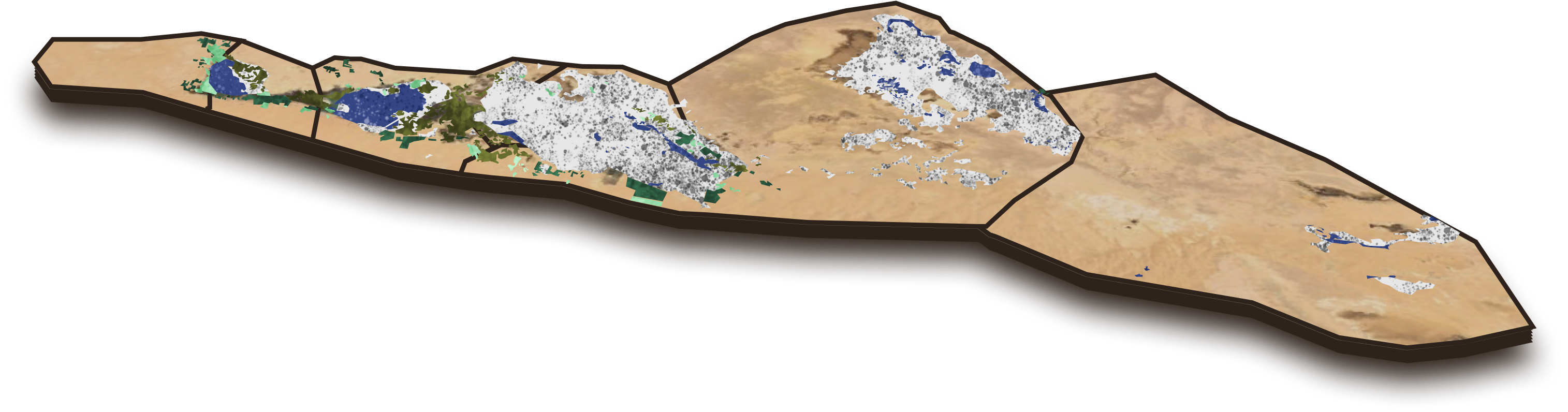
Water Surfaces 28.63 km2
Desert 100.6 km2
Salinization & Waterlogging 13.3 km2
Drainage 43.48 km2
Farmlands 35.57 km2
Ancient Farmlands 27.5 km2
Reclaimed Lands 8.08 km2

Water Surfaces

Salinization & Waterlogging

Farmlands

Desert

Drainage

Village Borders

Ancient Farmlands

Reclaimed Lands 2021

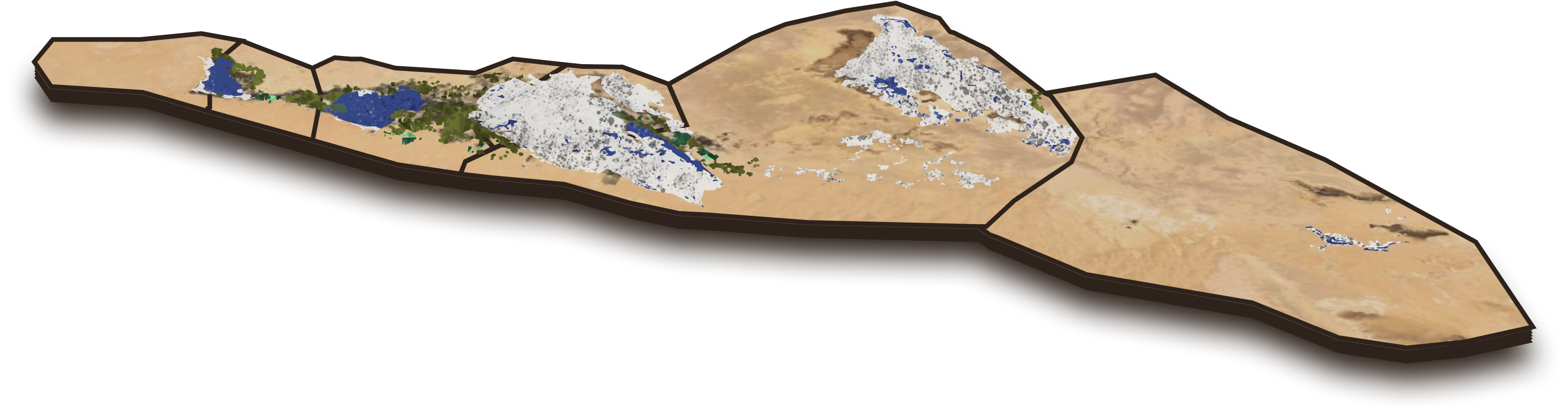
Water Surfaces 27.17 km2
Desert 91.7 km2
Salinization & Waterlogging 15.1 km2
Drainage 15.08 km2
Farmlands 32.61 km2
Ancient Farmlands 27.6 km2
Reclaimed Lands 6.72 km2
Water Surfaces
Salinization & Waterlogging
Farmlands
Desert
Drainage
Village Borders
Ancient Farmlands
Reclaimed Lands 2021

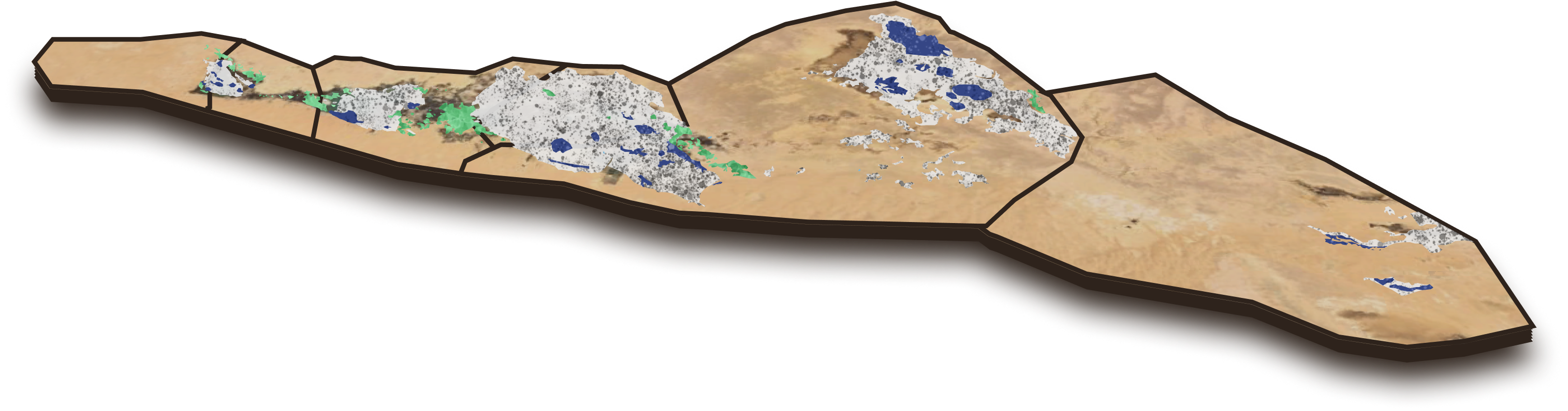
Water Surfaces 27.17 km2
Desert 104.1 km2
Salinization & Waterlogging 30.2 km2
Drainage 7.31 km2
Farmlands 23.67 km2
Ancient Farmlands 20.9 km2
Reclaimed Lands 3.35 km2
Water Surfaces
Salinization & Waterlogging
Farmlands
Desert
Drainage
Village Borders
Ancient Farmlands
Reclaimed Lands 2021
Water Surfaces 25.05 km2
Desert 111.3 km2
Salinization & Waterlogging 12.6 km2
Drainage 25.19 km2
Farmlands 21.41 km2
Ancient Farmlands 20.2 km2
Reclaimed Lands 4.51 km2
Water Surfaces
Salinization & Waterlogging
Farmlands
Desert
Drainage
Village Borders
Ancient Farmlands
Reclaimed Lands 2021

Water Surfaces 26.54 km2
Desert 116.4 km2
Salinization & Waterlogging 9.0 km2
Drainage 26.69 km2
Farmlands 17.52 km2
Water Surfaces
Salinization & Waterlogging
Farmlands
Desert
Drainage
Village Borders
Water Surfaces 5.34 km2
Desert 111.4 km2
Drainage 5.48 km2
Farmlands 22.36 km2
Water Surfaces
Salinization & Waterlogging
Farmlands
Desert
Drainage
Village Borders
Water Surfaces 3.48 km2
Desert 132.6 km2
Salinization & Waterlogging 42.2 km2
Drainage 3.62 km2
Farmlands 13.06 km2
Water Surfaces
Salinization & Waterlogging
Farmlands
Desert
Drainage
Village Borders
The problem faced by Haidar and other Siwa residents and farmers today is not new. In the late 1970s, farmers started noticing that agricultural run-off was hurting their palm, olive and pomegranate trees. At the time the region had 3,366 acres of farmland, irrigated by 69 million cubic meters of water annually.
In 1977 the Egyptian Agency for Reconstruction of the Northern Coast launched plans to reclaim the farming lands of Siwa and develop agricultural production and irrigation systems. A five-year plan was funded by the World Food Program, received by the Egyptian government as part of a package of assistance from the U.S. Agency for International Development.
Up until then, the local farmers depended on Siwa’s 220 natural springs and freshwater wells, according to the Ministry of Agriculture. The wells can be traced to the Roman era, and they were the only source of water in the oasis, which is located just north of the Great Sand Sea in northwest Egypt. Irrigation of agricultural lands was based on Strict tribal law, according to Sheikh Raji’.
By 1985 the amount of farmland had doubled to more than 6,000 acres. New wells were dug and more water was being pumped out of the aquifers. About 155 million cubic meters of water per year were being used for irrigation, due to the funding of the WFP project.
But no one was paying attention to the mounting problem of agricultural drainage, which was flowing into the peoples’ houses and threatening to drown the entire oasis, which is listed as a seed bank by the Food and Agriculture Organization (FAO), due to its plant genetic resources. The amount of damaged land began to grow, threatening the livelihood of almost everyone in the region.
The tribal chieftain at the time, Sheikh Ali Haida, reached out to officials in the Marsa Matruh Government, which oversees Siwa administratively. Receiving no response, the Sheikh reached out to Cairo directly and a meeting was arranged with officials in the Irrigation Ministry.

Point to review the data
Water Surfaces 3.48 km2
Desert 132.6 km2
Salinization & Waterlogging 42.2 km2
Drainage 3.62 km2
Farmlands 13.06 km2
Water Surfaces
Salinization & Waterlogging
Farmlands
Desert
Drainage
Village Borders
In the 1980s, damages resulting from agricultural drainage began to gradually escalate
Meanwhile, the farming town was still expanding. By 1998, about 12,000 acres of land were being farmed. Records from 1999 obtained from the Irrigation and Water Resources Ministry show 1,200 wells: 200 of them reaching depths of 1,200 meters, and the rest 20-25 meters deep. The wells were pumping 291 million cubic meters of water annually.
But the lack of two separate systems for irrigation and drainage was wasting 33 million cubic meters of overflowing underground waters and creating salty lakes. The aquifers were rising a the rate of almost 1 centimeter per year, according to a report from the International Union for Conservation of Nature published in the year 2000. With the soil becoming over-salinized and less productive, it was becoming harder for the farmers to make a living.
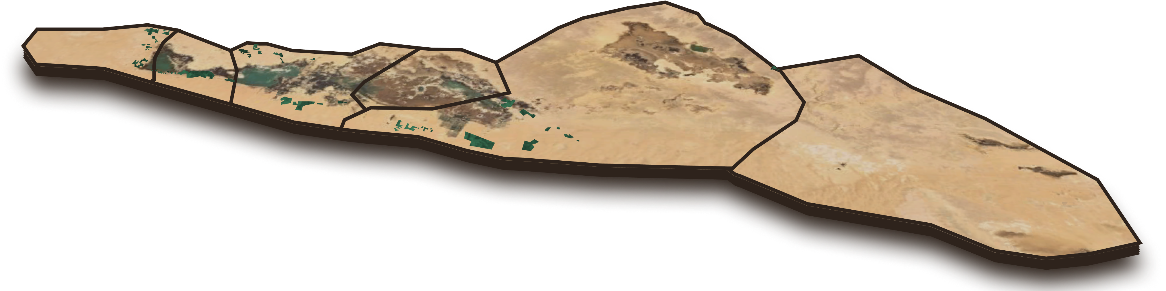
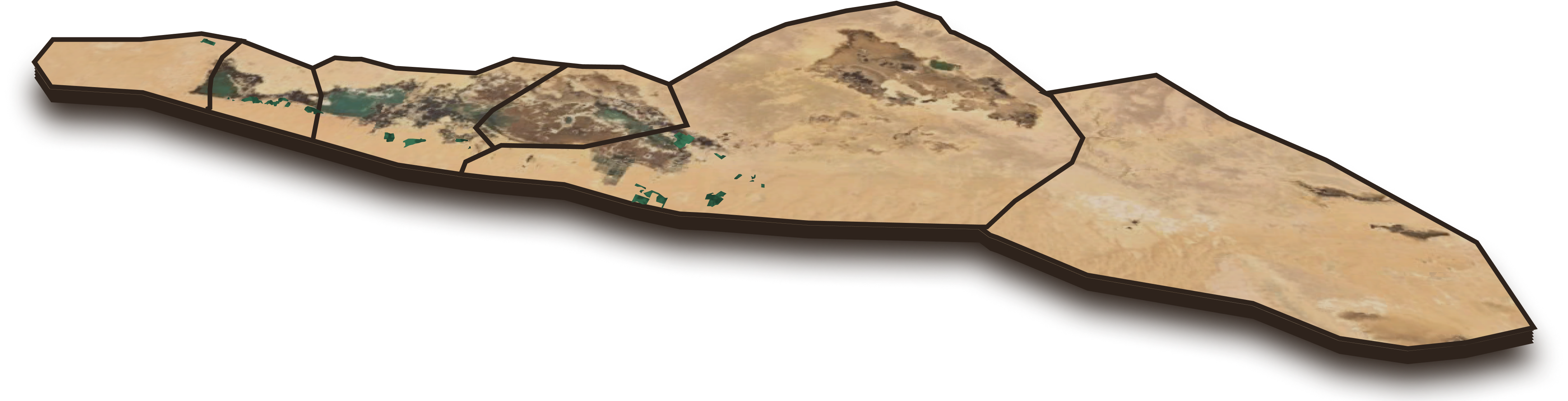
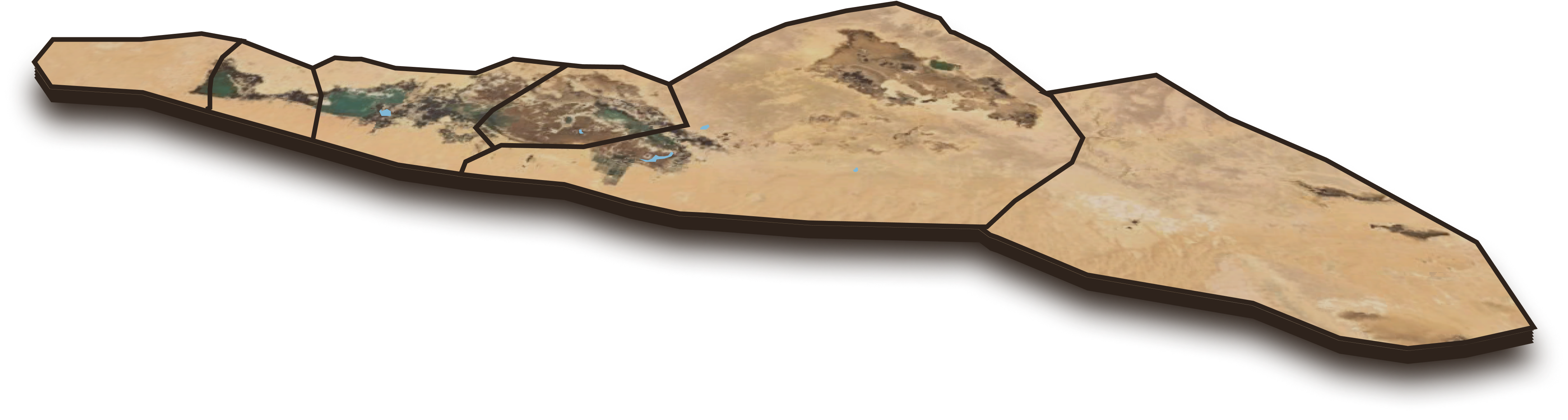
Siwa’s surface area was being taken over by water. Siwa Lake grew by 724% between 1990-2021. Al-Maraqi’s lake grew by 483% and surrounding lakes were growing fast as well. The only exception was the lake in Abu Shrouf, which shrunk by 79%.
Point to review the data

Water Surfaces 28.63 km2
Water Surfaces
Desert
Water Surfaces in the oasis
Sheikh Omar Raji’ said most of the damage was done after the visit of Mubarak in the mid-1990s. Agricultural investment boomed by orders of the government, and big investors and corporations were encouraged to work in the oasis. One company was given a huge tracts of land: 12,000 acres according Raji’. That was more than all the farms Siwa’s people tended to at the time.
Motivated by maximum profit only, the residents feel that the industrial farming corporations couldn’t care less about the damage they are doing to ancient Siwa. “These companies are represented by the government and they are part of the state’s economic activity,” according to Ashraf Mustafa, professor of soil sciences at Alexandria University. Mustafa oversaw a study of the desertification east of Siwa published in Alexandria Magazine in 2020.
“Expanding the amount of farmland and reclaiming land is a good thing,” said Abdul Hamid Najjar, professor of soil sciences at Al-Mansoura University. “But this expansion has come at the expense of the ancient farmlands, some of which have disappeared because of excess water. Other parts have become financially worthless due to desertification and salinity.”
Point to review the data
Water Surfaces 5.34 km2
Desert 111.4 km2
Drainage 5.48 km2
Farmlands 22.36 km2
Water Surfaces
Salinization & Waterlogging
Farmlands
Desert
Drainage
Village Borders
The escalation of damages caused by agricultural drainage in the 1990s of the past century
Mohammad Al-Sanusi is a prime example of what was happening to the people of Siwa. In 2000, he fixed up a parcel of land to plant olive trees. His dream was to make enough income to supplement his job as a teacher in a government school, so his family could have enough money to eat. For 10 years everything was fine, but in 2010 he started to notice that the trees weren’t producing their normal capacity. The green color was gone from the leaves, and every year there were less olives. By 2021 the agricultural run-off water had totally flooded his farm. “The olives were like coal. Everything died because of the salinity,” he said.
The same thing happened to Shaker Habboun, Al-Sanusi’s neighbor, who went into farming just like his father before him. He abandoned the family farm in Fatnas, which drowned, and he tried to reclaim another parcel of land. He’s using water desalinization solutions, and he says there is slight improvement, but nothing near normal production capacity.
This problem is affecting thousands of people in Siwa. The agricultural drainage problem is not only destroying the land, but is destroying the freshwater wells used for farming, including the ones dug by the government since the 1990s. “Most of the wells dug by the state in the Mubarak era are salinized,” said Raji’. Much of the land of Siwa is becoming unfarmable.
“The amount of wells dug out in the years after the Mubarak visit was unprecedent,” said Mamdouh Tuhami, who conducted a study on the desertification of Siwa Oasis in 2003. “What made things worse was the farmers who were digging wells randomly using primitive techniques. Some wells were dug in areas where the water is close to the surface, which is salinized, because it’s cheaper to dig there.”
Point to review the data
Water Surfaces 26.54 km2
Desert 116.4 km2
Salinization & Waterlogging 9.0 km2
Drainage 26.69 km2
Farmlands 17.52 km2
Water Surfaces
Salinization & Waterlogging
Farmlands
Desert
Drainage
Village Borders
Numbers and percentages of the damages escalate caused by agricultural drainage in the first and second decades of the third millennium.
Since the turn of the century, the original residents of Siwa have been joined by people from nearby towns who’ve flocked to Siwa to reclaim land. On top of that, Siwa has been invaded by huge agribusinesses like Express, Nouran and Palmera.

Major agricultural investment companies and areas managed in Siwa
New Egypt Countryside Development Corporation
Atlas Siwa Corporation
Ishraf Agricultural Investment Corporation
Green Agricultural Investment Corporation
Palmera Project
2,000 reclaimed acres – Atlas Siwa Corporation
2125 acres – Ishraf Agricultural Investment Corporation
3,000 acres – Green Agricultural Investment Corporation
317 acres – Used to launch the Palmera Project in January 2020
The government’s solutions have mostly been temporary amid the unfettered expansion of farming. Ismail Abdul Jalil, former head of the Desert Studies Center, said his organization has been warning since the 1980s, against planting on more than 8,000 acres until the agricultural drainage problems were solved. But the government chose to launch agricultural projects on more than 30,000 acres and only dealt with the crisis in a “partial and temporary” manner. “For example, they limited the number of wells but increased their depth,” he said.
Over time, Siwa’s lands will continue to lose quality and become unfarmable, according to a 2017 study from the College of Science at Al-Mansoura University. “We found that farmland was expanding excessively,” said Najjar, the soil professor from Al-Mansoura University, who took part in the study. “In 2015 it was 81 square kilometers, up from 22 square kilometers in 1992.”
Najjar added that over-salinized lands had expanded from 35 to 64 square kilometers over the same period. “And lands overtaken by wastewater went up from 19 to 51 square kilometers during those years,” he said.
In 2018, the International Panel on Climate Change reported that the Siwa oasis could drown due to the mismanagement of water and drainage.
Agurmi Lake
Zaytun Lake
Al-Maraqi Lake
Siwa Lake
The major lakes have been expanding every year since the 1970s due to agricultural drainage, covering more than 47,600 acres and increasing the salinity of the surrounding lands.
“When we started to measure the amount of land covered by water in Siwa, we used to see houses on the edge of the lakes,” said Mustafa, of Alexandria University. “Now, because of the agricultural drainage issue, we find that some of the houses are gone, and the others are right in the middle of the lakes.”
But all successive governments are doing exactly what the Mubarak government did: expand, reclaim, and invest in the agricultural lands in Siwa. In 2016, president Al- Sisi government unveiled “The 1.5 Million Acre Agricultural Investment” project as the first phase of an even bigger project aiming to boost the amount of farmland in Egypt by 4 million acres. That was 3 years before Al-Sisi promised to resolve the drainage crisis.
In parts of its second phase in 2018, the government plan called for granting 30,000 acres to agribusinesses. This made the farmers of Siwa more anxious, as their combined farmlands amounted to about 20,000 acres, according to Sheikh Raji’.
Click to browse the years
Reclaimed Lands 8.08 km2
Desert
Village Borders
Reclaimed Lands 2021

Reclaimed Lands 6.72 km2
Desert
Village Borders
Reclaimed Lands 2021
Reclaimed Lands 3.35 km2
Desert
Village Borders
Reclaimed Lands 2021

Reclaimed Lands 4.51 km2
Desert
Village Borders
Reclaimed Lands 2021
The area of reclaimed lands during the era of Mubarak and Al-Sisi during the period between 2005 and 2021
The Egyptian government has received millions of pounds in international assistance to fix the drainage issue and develop Siwa, especially since UNESCO considers the oasis to be a potential major destination for ecotourism.
But despite the investment, olive production – which amounts to 67% of the agricultural produce of the oasis – is down 55% in the ancient farmlands, according to a 2017 study on the economic effects of the rising water in Siwa. The report, published in the Agricultural Magazine, estimated that the cost of growing olive trees in the ancient lands was 79% higher than the new farmlands. It also estimated that the return on investment in the ancient lands was 49% per acre lower than the new farmlands.
Satellite imagery shows that the amount of reclaimed land rose by 302% between 2005-2021, from 9.5 square kilometers to 38 square kilometers. Most of the reclaimed land is in the Abu Shrouf Kafrawi area, up 457% during those 16 years. Other regions, like Bahiyuddin, central Siwa, Al-Maraqi and Aghurmi have also been targeted for agribusiness.
Point to review the data
Water Surfaces 28.63 km2
Desert 100.6 km2
Salinization & Waterlogging 13.3 km2
Drainage 43.48 km2
Farmlands 35.57 km2
Ancient Farmlands 27.5 km2
Reclaimed Lands 8.08 km2
Water Surfaces
Salinization & Waterlogging
Farmlands
Desert
Drainage
Village Borders
Ancient Farmlands
Reclaimed Lands 2021
Numbers and percentages of the damages caused by agricultural drainage in the year 2021
In Siwa city which is located in the middle of the oasis, the amount of land lost to drainage has shot up by 1101% between 1990-2021. The percentage of lost farmland ranges from 226-774% in the surrounding areas.
But in Abu Shrouf Kafrawi area, which had the most reclaimed land, drainage water receded by 68%.
Click to browse the years
Drainage 43.48 km2
Desert
Drainage
Village Borders
Drainage 15.08 km2
Desert
Drainage
Village Borders

Drainage 7.31 km2
Desert
Drainage
Village Borders
Drainage 25.19 km2
Desert
Drainage
Village Borders

Drainage 26.69 km2
Desert
Drainage
Village Borders

Drainage 5.48 km2
Desert
Drainage
Village Borders
Drainage 3.62 km2
Desert
Drainage
Village Borders
Map of irrigated lands through agricultural drainage from 1990 to 2021
By analyzing the data from the satellite imagery, we found that the amount of farmland increased in the oasis by 251%, and conversely the amount of desert decreased by 4% in the years between 1990 and 2021.
“All of the attempts to take the water out of Siwa have failed. They are all projects on paper only,” said Mustafa of Alexandria University. “In the past few years we, in Alexandria University, have participated in hundreds of meetings to resolve the drainage issue, and none of them have worked.”
In January 2022 the government launched a new project to improve the irrigation and drainage system to solve the issue “once and for all,” according to the press releases issued by the Irrigation and Agricultural ministries.
The new project carries the excess water away from the oasis, namely to the northeast part of Siwa, through a tunnel of reinforced concrete, supported by pumps, tanks and a distribution system. The water would end up in Ain Al-Janbi outside the oasis.
What happened to Haidar last June reminded him the first time his family had to leave their home, when drainage water would appear every once in a while. But every time it came back, the levels were higher.
He hopes the new projects will succeed so that he doesn’t have to evacuate for the second time, but he’s not sure it will happen. “We’ve heard many promises. The end result is what’s important.”
Sheikh Raji’ is optimistic this time around. He thinks the drainage issue will be resolved, which will allow him to reclaim his land and the land of his father – which have been destroyed.
Meanwhile, the government is going along with its strategy, which has been unchanged for the past 30 years: reclaiming farmland in Siwa and announcing developments to the water systems in place. To date the former is making progress, but the latter is not.
Abdulwahab Alioua, Ibrahim Hamada, Ahmed Ashour, Ithar Al-Azim, Maha Salah El-Din, Aya Al-Munaseer, Abdullah Qouqas, and Eman Munir
